Aerial Photos of Prince William County, Virginia - 1937
Show / Hide Interesting Finds
Interesting Finds
On image 113_044 you’ll see the town of Occoquan, the Occoquan Workhouse (Lorton Prison), the prison brick making plant, and the water treatment plant for the prison. In Alice Maude Ewell’s book titled A Virginia Scene or Life in Old Prince William, published just six years before this image was taken, she describes the town of Occoquan as “Here was all that I had heard of – and more. It is as hard sometimes to define the picturesque as the beautiful. It is simple thus and so. We can but gaze and admire” Those words still hold true today. On the other side of the river is the Occoquan Workhouse made of bricks cast in its own brink making plant. The 1930’s seemed a calm time for the prison but just a few years before it held some incredible women who changed history and the lives of women in this country and around the world. Alice Paul and Lucy Burns were two of note. Lucy is pictured to the right taken in Occoquan Workhouse about 1917. Of all women who fought for the cause she is said to be jailed the longest.

On image 132-131 you’ll find Ben Lomond historical site in the upper right corner. Just south of Ben Lomond on the right edge of the image is the original location of the Manassas Airport prior to it being relocated in 1964. To the southwest of the airport is the location of the present day Manassas Mall. To the northwest of the mall is the old Lewis Farm. One of the last original family farms left in the vicinity, if not the last. South of the mall location and north of the railroad tracks is the location of present day Stonewall Jackson High School.
On image 117_069 is Liberia Plantation, southwest of the middle of the image. During the time this image was taken Liberia was owned by a wealthy brewer, banker, and shipper from Alexandria, Virginia by the name of Robert Portner. The Portner family never lived at Liberia but developed the property into a successful dairy operation. It looks like the dairy operation was southwest of the main house down a long, narrow, tree lined path. Liberia is currently being restored by its present owner, the City of Manassas. A clearer view of what I believe is the dairy operation can be seen on image 117_115.
On image 117_115 you’ll see all of old town Manassas. The train station is visable in the image as well as the present day location of the Manassas Museum and a large open fied to the southeast of old town, the current location of Osbourn High School.
On image 117_073 you’ll see Lake Jackson and the old, low bridge that crossed the Occoquan river just infront of the dam. The image was taken just 10 years after the dam was built by Charles W. Alpaugh. In 1933 Alpaugh started selling 30x60ft lots for $40 out of the sales office which is now the red vertical log building currently being used as the sales center for Outdoor Home Center. In 1958, Richard L. Lester, Sr., an employee of Charles Alpaugh was shot to death in the upstairs apartment of the sales office. Charles Alpaugh’s son, Luther Alpaugh was charged with murder after fellow employee, William D. “Billy” Gavin said he witnessed the murder. Luther Alpaugh was cleared of the murder in 1959 and Billy Gavin eventually confessed to it. [source]
On image 117_098 near the middle right of the image is the oldest house in Prince William, Bel Air. It’s not the easily seen farm with the power line easement running through it, that was known as Smithfield and is long gone. It’s just south of that. During this time Bel Air is abandoned, it’s being vandalized, looted, and rumors of gold being hidden in the walls are causing people to rip it apart. Bel Air is a great property and has the most detailed Wikipedia page of any old structure in the county, by far. Interestingly Bel Air is labeled on image 117_010, but incorrectly. Southeast of Bel Air is Posey’s Corner. The family cemetery is north of this location on the property of Hylton High School today. West of Posey’s corner is present day Howison Homestead Park. The homestead was still active during this time with the last burial in the family cemetery being 1944.
On image 117_111 you’ll see Brentsville in the upper left of the image. It doesn’t look much different from what you see there today. After the county seat was moved from Brentsville to Manassas in 1894 the town dwindled in population. Hotels, ordinaries, and law offices closed and relocated where the work was. In Alice Maude Ewell’s book titled A Virginia Scene or Life in Old Prince William she claims, the only people who didn’t move out of Brentsville were those too poor to do so.
On image 132_004 near the lower left corner you’ll see Rippon Lodge. During the time this image was taken the property was owned by a Washington, D.C. federal judge and his wife, Judge and Mrs. Wade H. Ellis. Since purchasing the house and 500 surrounding acers in 1924 Judge Ellis renovated and preserved the property until his death in 1948. Today Rippon Lodge is beautifully restored and open to the public.
On image 113_179 near the top right is Hoadley, a small gathering of homes and a few small stores. Ida Davis ran a general store here in the 1930s following the death of her husband in 1927. Today this is the intersection of Hoadley road, Davis Ford road, and the Prince William Parkway.
In image 117_077 you'll see Civilian Conservation Corps. (CCC) Camp P-71 in the top right corner of the image and pictured to the right. This camp was part of the civil work projects of newly elected President Franklin D. Roosevelt's New Deal. The camp was built in 1933. South of the camp is a major roadway intersection with old Dumfries Rd.(Rt. 234), Joplin, and Aden roads coming together in a triangle. It looks similar today. On the north east side of Aden Rd. near the intersection with Joplin is the old Quantico Baptist Church. Today, there is just a few stones left from the foundation. The cemetery in front of the building was so overgrown a few years ago the cemetery was considered "lost". It has been cleaned up in recent years and is doing well.

In image 117_079 you'll see some of the area that today is Marine Corps Base Quantico. These images were taken a few years before the 1942 expansion that added 50,000 additional acres to the base. The area was home to many families at the time these images were taken. Their homes and churches were destroyed long ago but there are still several family cemeteries on the land.
On image 119_045 you’ll find the original layout of Pageland Road in the lower left corner of the image. Today it’s been realigned to remove the sharp turn. You can also see a cemetery near the lower left section of the image. You can see the cemetery on a google map today.
More Interesting Finds coming soon.
Click on any numbered tile to see the image. You can zoom and pan all images.
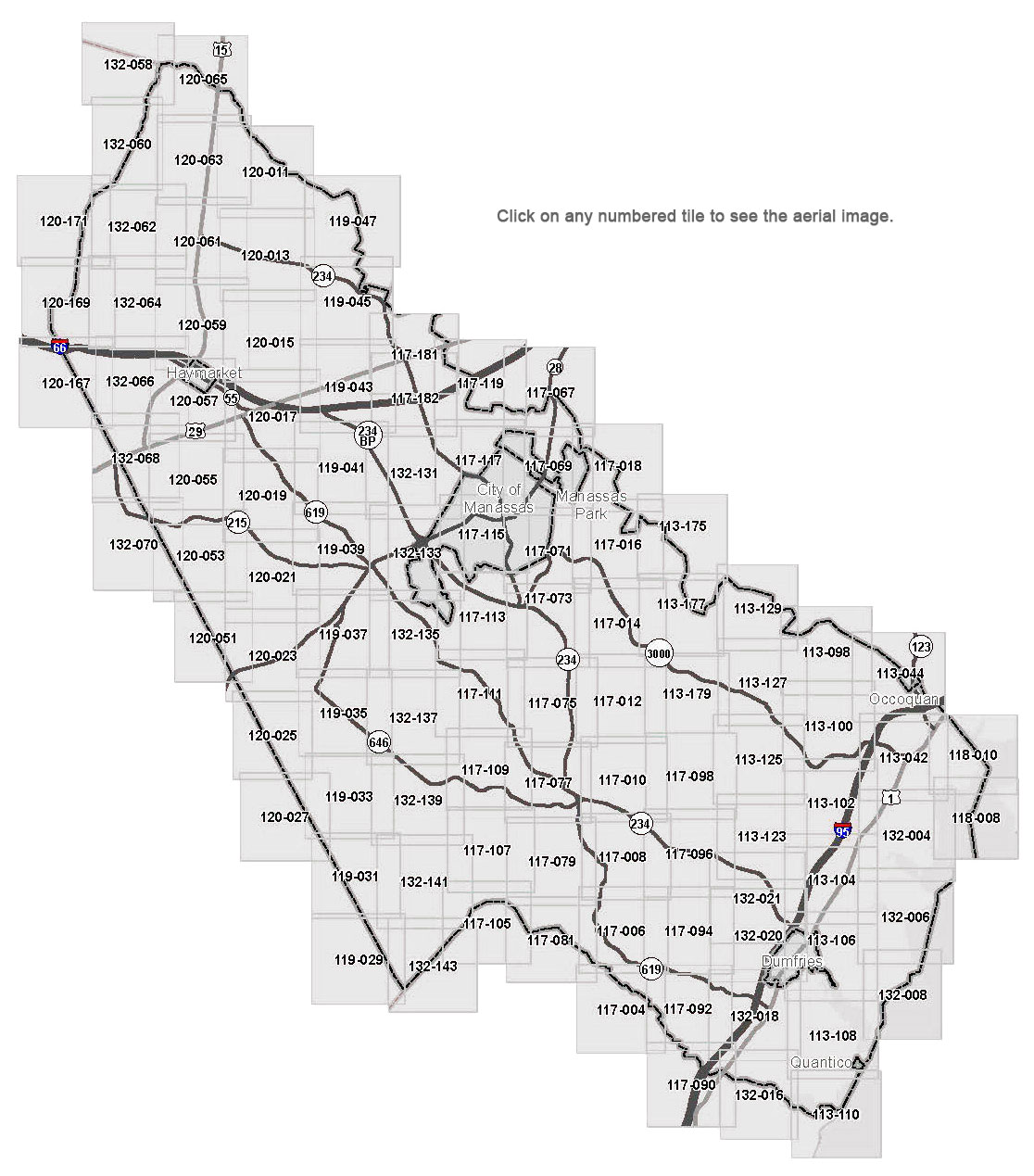
Download a pdf of any map tile by clicking on it below.
Image 113_044
Image 113_098
Image 113_100
Image 113_102
Image 113_104
Image 113_106
Image 113_108
Image 113_110
Image 113_123
Image 113_125
Image 113_127
Image 113_129
Image 113_175
Image 113_177
Image 113_179
Image 117_004
Image 117_006
Image 117_008
Image 117_010
Image 117_012
Image 117_014
Image 117_016
Image 117_018
Image 117_067
Image 117_068
Image 117_069
Image 117_071
Image 117_073
Image 117_075
Image 117_077
Image 117_079
Image 117_081
Image 117_090
Image 117_094
Image 117_096
Image 117_098
Image 117_105
Image 117_107
Image 117_109
Image 117_111
Image 117_113
Image 117_115
Image 117_117
Image 117_119
Image 117_181
Image 117_182
Image 118_008
Image 118_010
Image 119_029
Image 119_031
Image 119_033
Image 119_035
Image 119_037
Image 119_039
Image 119_041
Image 119_043
Image 119_045
Image 119_047
Image 120_011
Image 120_013
Image 120_015
Image 120_017
Image 120_019
Image 120_021
Image 120_025
Image 120_027
Image 120_051
Image 120_053
Image 120_055
Image 120_057
Image 120_059
Image 120_061
Image 120_063
Image 120_065
Image 120_067
Image 120_069
Image 120_071
Image 132_004
Image 132_006
Image 132_008
Image 132_016
Image 132_018
Image 132_020
Image 132_021
Image 132_058
Image 132_060
Image 132_062
Image 132_064
Image 132_066
Image 132_068
Image 132_070
Image 132_131
Image 132_133
Image 132_135
Image 132_137
Image 132_139
Image 132_141
Image 132_143