
Publications of Historic Prince William
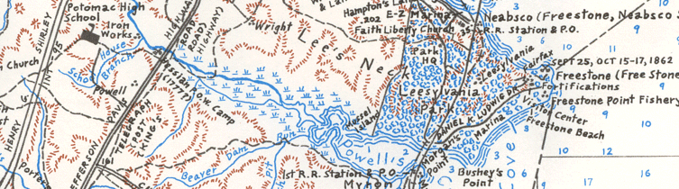
Historic Map, by Eugene Scheel
The Historic Map of Prince William County graphically locates roads, towns, schools, post offices and many other features of the area. Potomac River depths are marked as well as elevations. Special attention is paid to the First and Second Battles of Manassas, with insets of the battle. Several line drawings of noteworthy buildings decorate the map. The overall size is 33" wide by 37" high.
Crossroads and Corners, by Eugene Scheel
This book provides a tour of the villages, towns, and post offices of Prince William county, Virginia - past and present. It is a companion book to the 1992 historical map. ($10)
All prices include sales tax, but "Shipping and Handling" is extra:
Under $21: add $4.00 Shipping and Handling
$21-$35: add $6.00 Shipping and Handling
$35.01-$50: add $9.00 Shipping and Handling
Over $50: add $12.00 Shipping and Handling
Download, print, complete, and mail the order form.

Please make checks payable to Historic Prince William Inc., and send orders to us at:
Historic Prince William
P.O. Box 1731
Prince William, Virginia 22195-1731
You might also be interested in publications from the Prince William County Historical Commission (pdf information/order form).