Restoration Report for Reid Cemetery
Historic Prince William Inc.
P.O. Box 1731
Prince William, Virginia 22195
Prepared by David Cuff Nov. 5th, 2019
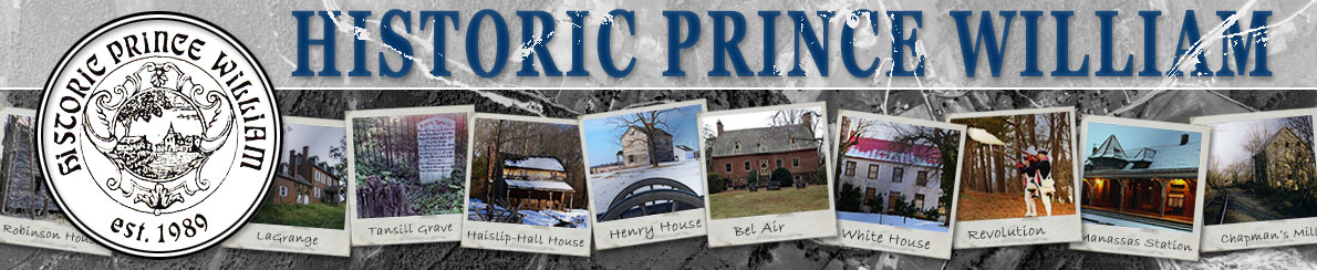
Location: 13344 Nickleson Dr., Woodbridge, Va 22193 (Image 1 below)
Land owner: Hylton Group
Need: The cemetery was vandalized in the mid-1990s and every headstone was broken with a blunt object.
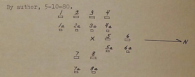
Prior site visits: REN Conner visited the cemetery in 1980 and transcribed all of the headstones and drew a map of the location of the stones (Image 2 below) and included it in his book titled 100 Old Cemeteries of Prince William County Virginia that was published in 1981. He noted that the cemetery was “in good condition”. Ron Turner visited the cemetery in 1992 and noted the cemetery was “in good condition”. He Revisited the cemetery in 1998 and noted that “most of the stones are broken off bases and some in as many as five pieces”. I first visited the cemetery in February of 2015 and noted that the cemetery was in horrible condition with “large stones are either missing or broken”. (Image 3 and 3a below)
Three phase plan:
Phase 1 - Clear the underbrush and small trees that are throughout the cemetery area.
Phase 2 - Unearthing the headstones and footstones, clean them, bond the broken pieces back together with two part epoxy, then bond the repaired section with the base in the ground.
Phase 3 - Periodic maintenance.
Action taken: Received approval from Conrad Hylton via Joey Pullen by email on March 8, 2019. Work began on Sunday, March 10th. I uncovered five buried stones on March 17th. Small trees were cut and dead sticks were picked up and put in a pile and hauled to the dump.
Branches on trees were cut within arm's length to provide a clear line of sight through the cemetery. (Image 4 below) The entire cemetery was raked and debris removed. Stones were located with a probe rod and uncovered.
The pieces for the headstones were taken to my house and washed, dried, dry fitted, and then epoxied together. Contraptions were made to hold the pieces in place while they cured and one of the contraptions was also used to transport the headstones back to the cemetery (Can be seen in image 5 below). It was purpose built for this project but will be reused on future projects as needed. The epoxy used hardens within a few hours but the pieces were left in place to cure for at least one week.
Once the individual pieces were epoxied into the shape of a headstone that section was taken back to the cemetery and bonded to the base with epoxy and clamped with wood and C clamps and left for 3 to 7 days. (Image 6 below)
All headstones and footstones were placed at their original locations on the original bases. The bases were not removed from the ground. I tried to dig up a couple of them to straighten them but they were too deep.
Two of the headstones were heavily damaged. Sarah Reid’s headstone was broken into 9 pieces (Image 7 below). The headstone for Addison P. Reid is so heavily damaged and has many missing pieces that it was not possible to be epoxied back together. A frame was made out of PVC trim boards and the pieces were laid on the ground within the frame in front of the undisturbed base.
The small headstone for the child named Redman Reid is missing. He only lived one day but there was a carved stone for him in the past. The red sandstone base is present but the headstone was never found.
The bank that runs along Dale Boulevard on the south side of the cemetery was also cleared and raked.
Prior to receiving approval from the Hylton Group to do the project a couple large trees were removed from the cemetery by a tree company contracted by the Hylton Group. This work caused no new damage to the cemetery or stones and the tree company removed every piece of tree they cut.
Cemetery identification stones were carved from slate pavers that I bought from the local garden center (Image 8 below and in place on image 9). There is one on the Nickleson Dr. side of the cemetery and there is another one on the backside along Dale Blvd. I decided to make cemetery identification markers rather than purchasing the bronze markers that we have used on other cemetery projects.
The cemetery is very fortunate to have longtime residents on both sides who mow the grass on the hill in front of the cemetery and they also watch over the cemetery. The Bailey family, on the west side have been there since 1977 and the Bogart family has been in the house on the east side since 1984. Both visited the cemetery several times while I was there.
Special thanks: I would like to thank the Baileys and the Bogarts for their efforts with the cemetery and also I would like to thank Robert Moser for assisting me with clearing the area. And I would also like to thank the Hylton Group for allowing me to do the project. It's uncommon for a cemetery restoration to need such extensive rebonding work with epoxies. I appreciate their willingness to allow me to undertake the task.
Contact: Historic Prince William can be visited at www.historicprincewilliam.org
Historic Prince William can be contacted at info@historicprincewilliam.org
David Cuff can be contacted at dave@dynamitedave.com
The webpage for the Reid Cemetery is https://www.historicprincewilliam.org/cemeteries/cemeteries-in-pwc/reid-dale-city.html
The cemetery map we maintain can be viewed at https://www.google.com/maps/d/u/0/viewer?mid=1nwAPoSshAbEr8f-FiDNdUho2Uq0
History: The Reid family is large and hard to trace but from what I have found they had a large 500 acre farm between Spriggs Road and the Hoadly area. This farm was likely where Hylton High School and much of the Princedale neighborhood is today. There is another Reid cemetery 0.6 miles south of this Reid Cemetery. It is the same family and was on the same 500 acre farm.Robert Moser and I have been to the cemetery and have cleared the overgrowth and sticks. We will be returning soon to upright some of the headstones. There doesn't seem to be any vandalism at the cemetery. The headstones have just fallen due to gravity. This cemetery has no ownership listed on the county mapper. It is landlocked by private property on all sides but a property owner allows us to walk across his property for access.
Image 1 - Location in Dale City. 0.3 acres
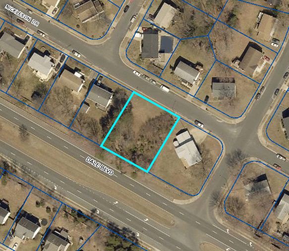
Image 2 - From REN Conner’s book. Shows the layout of the stones.
Inscriptions from REN Conner’s book. The number above correlate to the list below.
1. SARAH REID Why do we mourn departing friends or shake at death's alarms tis but the voice that Jesus sends to call them to his arms 1a. S R |
5. REDMAN Son of J. B. & M. V. Reid 5a. R R |
|
2. ADISON P. REID When blooming youth is snatched away by death's resistless hand our hearts the mournful tribute pay which pity must demand 2a. A P R |
6. JAMES M. Son of J. B. & M. V. Reid Died Oct 30, 1860 6a. J M R |
3. WILLIAM REID Tis God that lifts our comforts high Or sinks them in the grave he gives, and blessed be his name he takes, but what he gave 3a. W R |
7. MARGARET A. REID Died April 15, 1900 Where anchored safe my weary soul shall find eternal rest nor storms shall beat, nor billows roll across my peaceful breast 7a. M A R |
4. LYDIA REID A precious one from us has gone a voice we loved is stilled a place is vacant in our home which never can be filled 4a. L R |
8. LOUISA REID Born MARCH 27, 1821 Died JAN 9, 1892 Why should we start and fear to die what timorous worms we mortals are death is the gate to endless joy and yet we dread to enter there 8a. Lo. R |
Image 3 - Picture taken by David Cuff, Feb, 2015. This image shows a large tree in the upper left of the picture that was removed by the Hylton Group prior to the restoration. The top of it was dead.
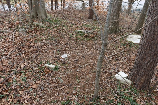
Image 3a - Shows what the area looked like when the project began in early March 2019. This was in early spring. Several small trees and young bushes have taken over the area.
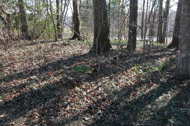
Image 4 - Shows the cemetery after the initial clearing of fallen sticks and the clearing of small trees.
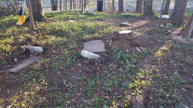
Image 5 - This image shows the contraption made to hold the stones during epoxy application and it is also used to transport the joined slabs back to the cemetery with a wheel dolly.
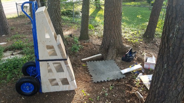
Image 6 - This image shows two more headstones that were cleaned and bonded to the undisturbed bases.
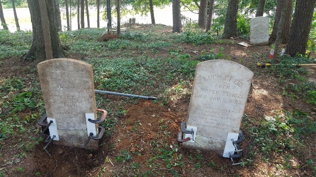
Image 7 - This headstone was the most damaged. It was broken into 9 pieces. After it was broken it laid on the ground and was eventually covered with a couple inches of decomposed plant matter. This hid it from view and was only found by probing the area. This protected the pieces from further damage or misplacement by humans.
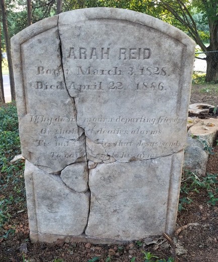
Image 8 - Shows one of the marker stones I carved. This was the first one I did. It’s done by hand with thin chisels and a Bell Hammer (it’s called a “dummy hammer” in the UK, where more letter carving in stone is done)
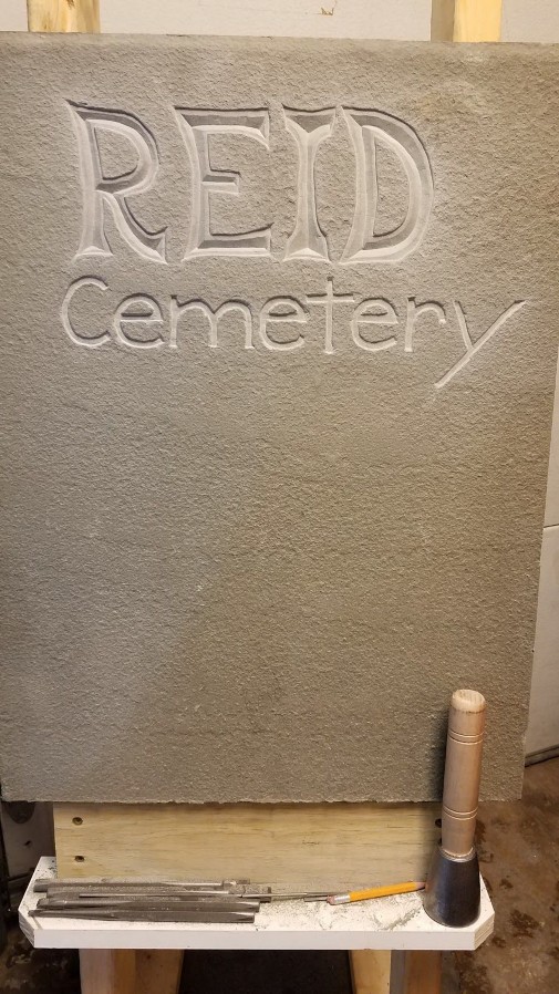
Image 9 - Shows how open the cemetery is now. This image was taken Nov. 6th 2019.
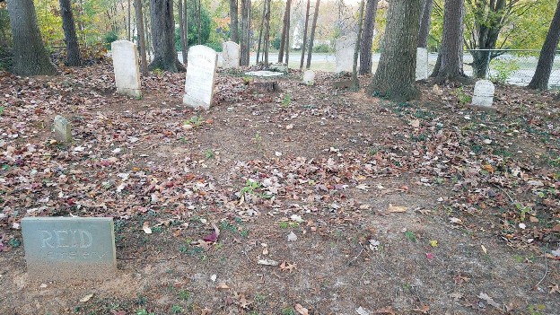
Image 10 - From the 1901 William Brown Map showing the Reid Farm Location
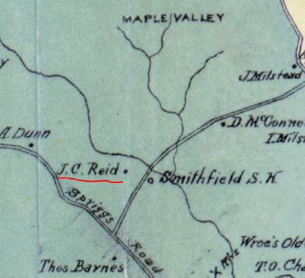
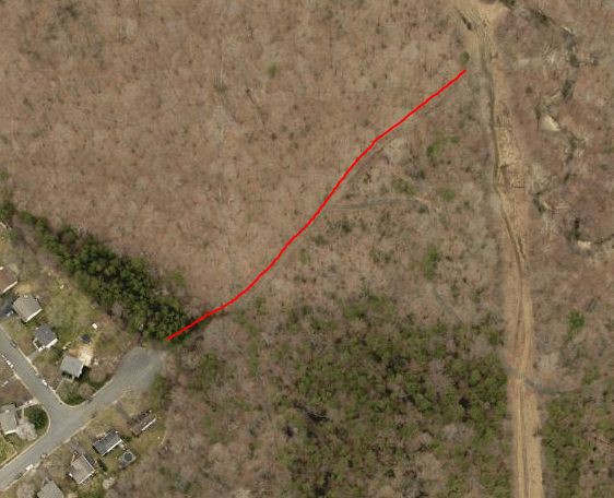
Image 11 - In this 1937 aerial image you can see the cemetery marked in the blue outline. Spriggs Road is in the lower left hand corner running diagonally. The open farm area in the middle of the image was the Reid Farm. The road traveling through that farm area heading north past the cemetery goes to the Hoadly or Maple Valley area which today is the area of the Prince William Parkway and Hoadly Road intersection. The section of the road outlined in red still exists today. It is a trail at the end of Portland Dr. (Image 12 below)
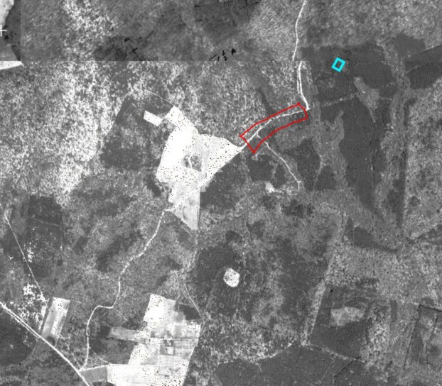
Image 12 - Modern day aerial image showing section of old road that is now a trail.
The end.